The Hurricane that Broke Savannah 32.079861° -81.091488°
32.079849° -81.091614°

Hey, everyone!
Is this a great day for a podcast, or what?
No storms… no bad weather… at least not for me where I am.
Sorry if you are. You know the old saying… If you don’t like the weather stick around… It’ll change.
So stick around I’m going to tell you a story about a bad day… weather wise
See, in Savannah and South Georgia, back in 1881, they had a really bad day.
A devil of a hurricane…
The carnage started several miles south of the city where at the sportsman’s club on Wolf Island, the home of the club’s caretaker, Mr. Stokes, was ripped from the foundation and pushed into the river. Floodwaters crashed in the doors and windows and swept his wife and children into the river. His entire family drowned. Only Stokes survived and walked over sixty miles to Savannah to report the event.
I’m JD Byous. Welcome to History by GPS, where we travel through history and culture GPS location by GPS location. So, click on your favorite map app and follow along. Today I’m going to give you a general GPS location which right in the main square of the city, Johnson Square, then, you can find the other places mentioned on our website, HistoryByGPS.com.
Now… that location in Johnson Square is where the weather station kiosk used to sit… before the storm… and the coordinates are
32.079861° -81.091488°

From East Broad Street to West Broad Street few buildings escaped the fury and damage of the storm.” As you may know, West Broad is now MLK Blvd should you be visiting Savannah…
This hurricane predated the naming of storms by almost seventy years. In 1881 it was called simply “Hurricane Five” and was only a class 2 hurricane, but Seven hundred people died in the area around the city, with 355 of that total within the city limits. It was one of the deadliest hurricanes in American history.[1]
The Mayor’s Report for the year reported that “A hurricane of unparalleled violence occurred on the 27th of August last, doing great damage to property in the city and vicinity. … and all of the buildings belonging to the city were more or less injured… The fire alarm telegraph wires were broken in many places and leveled to the ground, and a great number of shade trees blown down. The fences and railings enclosing the parks and squares and at Laurel Grove Cemetery were partially blown down and crushed by falling trees.”
As one newspaper described, the Class 2 hurricane that hit Savannah in August 1881 was one of “unparalleled violence… all of the buildings belonging to the city were more or less injured.” And almost all of the buildings in the city had wind or rain damage.
In the Atlantic, it started as a tropical storm and rolled to the northeast through the Lesser Antilles Island on August 22, and then it bounced up… off of Florida and headed to Savannah. By August 24, it reached hurricane strength. On August 27, it hit land directly at the mouth of the Ogeechee River at high tide, pushing a fifteen-foot storm surge.
In Savannah, wind gusts blew the city wind gauge away after recording a wind speed of 80 miles per hour. The intense damage resulted because Hurricane Five, though it was only estimated to be class two in strength, well, it came to Savannah… and it stayed for two days.
Hmmmm… that’s about the same length of time the tourists hang around here.
Anyway…
Small but slow storms can do as much or more damage as larger storms.
After wreaking havoc on the area, the hurricane beelined due west.
At the old savannah Morning News building on the corner of Bay and Whitfield Streets, the squall peeled the roof like a key-rolled tin top on a sardine can. The damage was severe because the water came through the ceiling into the editorial and make-up departments, then into the press and paper storage rooms. As one Alabama newspaper described, “The compositors finished their work ankle-deep in water.”[2]
The news must get out you know…
At City Market, the buildings sustained damage – many of those structures are still there – Also damaged was the old Exchange buildings that stood where the gold-domed City Hall stands today. The trees around the area fell and smashed fences, business signs, and lampposts, strewing trash debris across the streets and intersections.
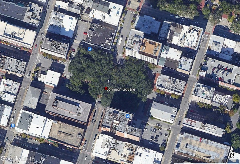 Johnson Square in Savannah where the weather kiosk was located.
The black communities along the waterways were hardest hit. David Bowens, his wife, and his children were washed into the river, -- all of them drowned. South of Savannah, on Shad Island, just downstream from Fort McAllister on the Ogeechee River, Henry Douglas’ wife and four children were lost when the surge rose and swept them into the marsh. Other huts on the waterways suffered the same fate. All of the residents of Douglas’ small fishing settlement died in the storm, with the exception of Douglas.
The plantation of former Fort McAllister commander Major George W. Anderson on the Ogeechee Road was hit with winds strong enough to blow down his barn, killing two of his horses that were inside. Some of you history buffs may remember that that plantation was where Union General William Tecumseh Sherman made his headquarters when he surrounded Savannah in 1864. I’ll talk about that incident and the capture of Fort McAllister in another episode.
Oh, I forgot. Remember to follow the podcast that way you’ll be notified when new episodes come out. If you’re watching on YouTube, subscribe. You know how to do it… click the button.
Also go to HistoryByGPS.com where you’ll find other GPS locations mentioned on this episode. You’ll also find our merchandise and books. We have tee-shirts, cups… other things… as well as products mentioned on this episode and others that highlight Savannah, Georgia.
Oh, if you have any information you want to give, or state your opinion on this topic, please go to the comments and write it… it’s on the website.
I’d love to hear from you.
 Overview of damaged area around Savanah.
Now back to newspaper articles.
The Round House plantation that Joseph Clay owned was totally demolished.
All of the buildings and many of the animals were blown into the river and washed away.[1]
One article on the storm claimed that on August 26th, the Savannah Morning News had an article about the storm, but the U.S. Signal Corps issued no official warning.
August 27 was a Saturday, and despite some squally weather in the morning, many people went to Tybee Island to the beach, and to escape the heat. The fresh northeasterly wind may have seemed welcome after a long summer of steamy heat in the city.
The early morning ferries had brought hundreds to the Tybee wharf, where a mule-drawn streetcar drove people to the beach and the Ocean House, a 40-room hotel with a large, popular restaurant.”
But by lunchtime, it was too late. The water was too rough for the ferries to run… and, at that time, there was no road from Tybee Island to the mainland.
Another article said, In Savannah itself, the damage was horrific. Almost all buildings lost their roofs. Including major buildings like the Savannah Cotton Exchange, the office of the Savannah Morning News, and the U.S. Signal Corps. When the U.S. Signal Corps building was destroyed, along with the weather instruments, the barometer was 29.08”, and the wind was 85 mph, but the storm continued to worsen.
All of the accounts of the 1881 hurricane stress the extreme “violence” of the wind in the city.
Savannah proper was out of reach of the tides because it sits around forty feet about the river, so the tidal surge couldn’t reach it on the high bluff. But the winds were enough to cause terrible damage on their own. The death toll in Savannah itself was 335 from collapsing buildings, flying tin roofs, collapsing chimneys, flying glass, and falling trees.
As accounts from outlying communities came in, and from the poor black housing, the low marshes and riverbanks, and from Tybee, the death toll on land surpassed 700.
Experience has shown us that deaths from hurricanes, especially in poor, outlying black communities, were poorly documented. This has as has a similar study of the 1893 Sea Islands hurricane.
 Tybee Island beach and the Lazaretto Creek Station to the west.
The Station at Lazaretto Creek on Tybee Island became a ruin of tangled lumber, sails, lines, and palm limbs.
The wreckage included the wharf, the boats, the houses, the furniture, and all of the medical supplies.
The crew of the Spanish bark, Marietta, abandoned ship earlier in the night and rode out the storm hanging from the rafters hospital. Later, the men found that their ship was still afloat, but the mast and all of the rigging had been blown away.
Residents in Savannah weathered the storm in darkness because, as I mentioned earlier, the gas streetlight globes were smashed by the debris that found them in the path. The damage was the worst that any of the oldest city residents could remember. Even the devastating storm of 1854 brought less damage than the long-duration winds of that 1881 tempest.[3]
Leaving Savannah, the devil storm moved westward, damaging forest and property only to fizzle out in Mississippi, two states to the west.
And things changed at over at Trustees’ Garden, though it was unchronicled in newspapers. In the wake of the destruction, the renovation of the gasworks’ retort building changed it into the style we see today, holding the same five-bay footprint. A stone plaque on the northwest corner of the Morris Center across from the Pirates’ House Restaurant, commemorates the event, suggests a near-total rebuild. That old building dates from about 1853… at least in part… and was the retort building where they cooked coal to make streetlight gas for about one hundred years. After the hurricane, a more substantial structure wrapped around the columns to form a shell-like cover making the lighter-colored brick columns of the building seen today, should you visit there.
Across Morris Park to the southeast, on the west end of the old Kehoe Iron Works main foundry, the pillars for the enclosure hid evidence of the same catastrophic damage...for over a century.
A few years ago, I was a history consultant for the renovation project at Trustees’ Garden. I found that a lot of hurricane damage from 1881 was hidden under façades of bricks and mortar.
The hurricane’s damage was finally revealed in the archaeological record 134 years later while… very talented… artisans repaired and renewed the structure. You could see the old, shattered wall and pillar sections under the newer brickwork that stands today.
Mother Nature and old buildings are a lot like people… I suppose.
Time tends to cover and plaster over old damage… and usually, that damage is still buried under layers of tears and patches and Band-aids. For buildings physical and structural. For people, it’s physical and psychological.
As for the devil storm… it left Savannah, it moved westward, damaging forest and property to finally fizzle out over in Mississippi on August 29.
Sooo… if you didn’t know already know this story….. now you know.
Don’t forget to check out our books and merch at HistoryByGPS.com and leave a comment… I’d love to hear from you.
See you next time.
Bye.
Coordinates
Johnson Square weather kiosk 32.079849° -81.091614°
Wolf Island GA 31.348359° -81.304902°
Shad Island 31.886639° -81.163969°
Savannah Morning News Building GPS 32.081118° -81.092423°
Round House Plantation 31.925800° -81.276473° Later the land was owned by automobile tycoon, Henry Ford.
Station at Lazaretto Creek 32.014094° -80.882525°
Trustees’ Garden 32.078480° -81.083407°
[1] http://neh.ghslearn.com/interactive-case-study/primary-sources/primary-source-4/
[1] The National Hurricane Center began giving them names like Irma and Andrew in 1950. https://www.nhc.noaa.gov/aboutnames_history.shtml
[2] Swept to Death By the Gale, Great Destruction and Loss of Live in Savannah, Birmingham Iron Age, Birmingham, Alabama, Sept 8, 1881.
[3] Mayors Report, City of Savannah, Edward C. Anderson, 1855: The Storm at Savannah, Further Particulars, Southern Weekly Banner, Athens, Georgia, Tue Sept 6, 1881, p 1: Wikipedia, 1881 Atlantic Hurricane Season, https://en.wikipedia.org/wiki/1881_Atlantic_hurricane season: Donna R Causey, The 1881 hurricane of Savannah, Georgia nearly wiped out the town, Days Gone By, daysgonby.me, August 27, 2016.